UrbanSim
Introduction
UrbanSim is a microsimulation land use model, designed to support the need of Metropolitan Planning Organizations (MPOs), cities and other organizations for analyzing the potential effects of land use policies and infrastructure investments on the development and character of cities and regions. The modeling system relies upon a data-driven, transparent, and behaviorally-focused methodology that is designed to attempt to reflect the interdependencies in dynamic urban systems, focusing on the real estate market and the transportation system, and on the effects of individual and combinations of interventions on patterns of development, travel demand, and household and firm location. UrbanSim has become the operational modeling approach for a variety of metropolitan areas in the United States and abroad, and is actively used by a wide variety users ranging from academic researchers to private consulting firms to city and regional governments. UrbanSim has been operationally used across the United States in a variety of geographies ranging in metropolitan size from 100,000 to 9.6 million in population and include: Albuquerque, Austin, Boston, Chicago, Denver, Detroit, Eugene-Springfield, Honolulu, Kansas City, Minneapolis-St Paul, Nashville, Philadelphia, Phoenix, Salt Lake City, San Diego, San Francisco, and Seattle and internationally including: Johannesburg, Melbourne, Paris, and Vancouver among others. Over 81.8 million people live in areas covered by regional plans informed by UrbanSim.
UrbanSim has been developed from over more than a decade of research led by Paul Waddell, currently Professor of City and Regional Planning at the University of California, Berkeley, from multiple grants from the National Science Foundation and from a number of MPOs in the United States. The research behind UrbanSim has been cited widely in the academic literature. In reviews of advanced models by independent studies such as the National Cooperative Highway Research Program (NCHRP), UrbanSim has consistently emerged as one of the most sophisticated and credible land use modeling methodologies. The core model code has been developed in the Python programming language as Open Source software and is publicly available on the Urban Data Science Toolkit GitHub page.
Intended Uses of UrbanSim
UrbanSim has been developed to support land use, transportation and environmental planning, with a specific focus on the regional transportation planning process. Intended use cases of UrbanSim include the following:
Predicting land use information (e.g. real estate development and prices, and the location and types of households and businesses) for input to a travel model, for periods of 10 to 40 years into the future for regional transportation planning purposes.
Predicting the effects on land use patterns from alternative investments in transportation infrastructure, or in alternative transit levels of service, or roadway or transit pricing, over long-term forecasting horizons. Scenarios can be compared using different transportation network assumptions, to evaluate the relative effects on development from a single project or a more wide-reaching change in the transportation system, such as extensive congestion pricing.
Predicting the effects of changes in land use regulations on land use, including the effects of policies to relax or increase regulatory constraints on development of different types. Examples using the parcel-level model can include the assessment of the effects of an increase in the allowed Floor Area Ratios (FAR) on specific sites, or allowing mixed-use development in an area previously zoned only for one use.
Predicting land use development patterns in high-capacity transit corridors.
Predicting the effects of environmental policies that impose constraints on development, such as protection of wetlands, floodplains, riparian buffers, steep slopes, or seismically unstable areas.
Predicting the effects of changes in the macroeconomic structure or growth rates on land use. Periods of more rapid or slower growth, or decline in some sectors, can lead to changes in the spatial structure of the city, and the model system is designed to analyze these kinds of shifts.
Predicting the possible effects of changes in demographic structure and composition of the city on land use, and on the spatial patterns of clustering of residents of different social characteristics, such as age, household size and income.
Examining the potential impacts on land use and transportation of major development projects, whether actual or hypothetical. This could be used to explore the impacts of a corporate relocation, or to compare alternative sites for a major development project.
Assumptions and Limitations of UrbanSim
UrbanSim is a model system, and models are abstractions, or simplifications, of reality. Only a small subset of the real world is reflected in the model system, as needed to address the kinds of uses outlined above. Like any model, or analytical method, that attempts to examine the potential effects of an action on one or more outcomes, there are limitations to be aware of:
Boundary effects are ignored.
Interactions with adjacent metropolitan areas pose modeling difficulties due to boundary effects.Land use regulations are assumed to be binding constraints on the actions of developers.
This is equivalent to assuming that developers who wish to construct a project that is inconsistent with current land use regulations cannot get a waiver or modification of the regulations in order to accommodate the project. For the purposes the model system, this limitation allows for more straightforward comparisons of policies to be made under the expectation that land policies are enforced.Large scale and microscopic events cannot be accurately predicted.
While this limitation applies to any and every model, not just UrbanSim, it bears repeating since the microscopic level of detail of UrbanSim leads to more temptation to over-invest confidence in the micro-level predictions. No individual prediction made by the model, such as the development of a specific development project on a single parcel in a particular year 20 years from now, is likely to be correct. But the tendencies for parcels in that area to have patterns or tendencies for development is what the model is intended to represent. Model users should therefore not expect to accurately predict largescale, idiosyncratic events such as the development of a specific high-rise office building on a specific parcel. It would be advisable to aggregate results, and/or to generate multiple runs to provide a distribution of results. A related implication is that the lower level of sensitivity and appropriate use of the model system needs to be determined by a combination of sensitivity testing, experience from use, and common sense.Behavioral patterns are assumed to be relatively stable over time.
One of the most common assumptions in models, and one rarely acknowledged, is that behavioral patterns will not change dramatically over time. Models are estimated using observed data, and the parameters reflect a certain range of conditions observed in the data. If conditions were to change dramatically, such as fuel prices tripling and continuing to increase, it is probably the case that fundamental changes in consumption behavior, such as vehicle ownership and use, would result.
UrbanSim Overview
UrbanSim works at the microsimulation level representing individual persons and households, and when using the parcel-level model, UrbanSim represents individual parcels, buildings and even housing units within buildings. UrbanSim simulates the interactions among households, businesses, and developers within real estate markets. By modeling how households trade off housing costs, accessibility, and housing and neighborhood amenities, UrbanSim microsimulates households’ choices to move within a year, make a new location choice, and to rent or own. UrbanSim also microsimulates employment dynamics, including firms’ location choices. Furthermore, the model microsimulates developers’ choices of what kind of buildings to build, where, and when, and whether to redevelop existing properties. Land use policies constrain what developers can build, and transportation plans modify accessibility patterns, which influence the attractiveness of different locations for households and firms. This influences prices and rents and the market conditions for new development or redevelopment.
UrbanSim is different from prior operational land use models that are based on cross-sectional, equilibrium, aggregate approaches in that UrbanSim models individual households, jobs, buildings and parcels (or census blocks or zones depending on the template used), and their changes from one year to the next as a consequence of economic changes, policy interventions, and market interactions. UrbanSim simulates changes for each year, and the results of one year provide the starting point for the next simulation year. This method closely replicates the way that urban areas evolve, year over year, with mismatches between the supply and demand of housing and jobs. Typically, metropolitan areas see only a small fraction of the housing stock added in a given year. Development of real estate proceeds slowly in response to rapid changes in demand, leading to swings in vacancy rates and prices, and to the commonly observed booms and busts in real estate cycles.
Key conceptual underpinnings of UrbanSim include:
Representation of individual decision-making agents such as households, firms, persons and jobs.
Representation of the supply and characteristics of land and of real estate development a fine spatial scale from parcels and buildings to census blocks or user-defined zones.
The adoption of a dynamic perspective of time, with the simulation proceeding in annual steps, and the urban system evolving in a path dependent manner.
The use of real estate markets as a central organizing focus, with consumer choices and supplier choices explicitly represented, as well as the resulting effects on real estate prices. The relationship of agents to real estate tied to specific locations provides a clean accounting of space and its use.
The use of standard discrete choice models to represent the choices made by households and firms and developers (principally location choices). Although more sophisticated choice model structures can be used, the most common in practice is the Multinomial Logit Model (MNL).
Integration of the urban simulation system with existing transportation model systems, to obtain information used to compute accessibilities and their influence on location choices, and to provide the raw inputs to the travel models.
Model System Design and Geographic Level of Analysis
The architecture of the UrbanSim model system varies slightly from one model template to another. UrbanCanvas Modeler supports the three UrbanSim model templates below. Each utilizes the same UrbanSim core but have different data requirements and operate at different spatial resolutions.
Model Templates
The components of UrbanSim are models acting on the objects in the figure below, simulating the real-world actions of agents acting in the urban system. Developers construct new buildings or redevelop existing ones. In the parcel-model, buildings are located on land parcels that have particular characteristics such as value, land use, slope, and other environmental characteristics. When models are applied at any geography larger than the parcel, such as census blocks or zones, building records are structured as aggregations of individual buildings with an aggregated unit count and square footage within the specific building type and block. Governments set policies that regulate the use of land, through the imposition of land use plans, urban growth boundaries, environmental regulations, or through pricing policies such as development impact fees (available in the parcel-level model). Governments also build infrastructure, including transportation infrastructure, which interacts with the distribution of activities to generate patterns of accessibility at different locations that in turn influence the attractiveness of these sites for different consumers. Households have particular characteristics that may influence their preferences and demands for housing of different types at different locations. Businesses also have preferences that vary by industry and size of business (number of employees) for alternative building types and locations.
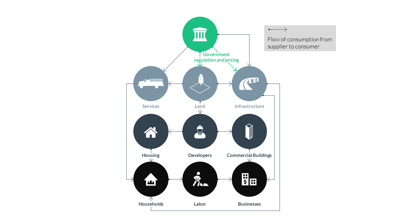 UrbanSim simulates agents interacting within real estate markets
UrbanSim predicts the evolution of these entities and their characteristics over time, using annual steps to predict the movement and location choices of businesses and households, the development activities of developers, and the impacts of governmental policies and infrastructure choices. The land use model can be interfaced with a metropolitan travel model system to deal with the interactions of land use and transportation. Access to opportunities, such as employment or shopping, are measured by the travel time or cost of accessing these opportunities via all available modes of travel. See the travel model integration section for details.
The typical data inputs and outputs for operating the UrbanSim model are listed below. Once the database is compiled, the model equations must be estimated using local data, and the full model system must be calibrated. A final step before actual use of the model is a validation process that tests the operation of the model over time and makes adjustments to the dynamic components of the model. For users of the block-level model, the base data for your region has already been complied into a database, the UrbanSim model coefficients for your region have been estimated and the model has been calibrated and validated. For users of the parcel-level model, these steps can be associated with a consulting contract.
UrbanSim takes several key inputs as exogenous, meaning that these are input assumptions that are not predicted directly by UrbanSim. Two of these are from external model systems: a macroeconomic model to predict future macroeconomic conditions such as population and employment by sector, typically derived by a state demographer, and a travel demand model system to predict travel conditions such as congested times and composite utilities of travel between each interchange. The latter is loosely coupled to UrbanSim, with land use predictions input to the external travel models, and travel conditions input to subsequent annual iterations of the UrbanSim land use model system.
Summary of Typical UrbanSim Data Inputs and Outputs
Typical UrbanSim Inputs
All model templates:
Employment data, usually in the form of geocoded business establishments, but alternatively from zonal employment by sector from sources such as the census Longitudinal Employer-Household Dynamics (LEHD)
Household data, merged from multiple census sources
City and County General Plans and zoning
Environmental features such as wetlands, floodways, steep slopes, or other sensitive or regulated lands
Traffic Analysis Zones (TAZs)
GIS overlays for any other planning boundaries
Travel Model outputs
Parcel model template only:
Parcel database, with acreage, land use, housing units, nonresidential square footage, year built, land value, improvement value, city and county
Development Costs
Typical UrbanSim Outputs
Households by income, age, size, and presence of children
Employment by industry and land use type
Acreage by land use
Dwelling units by type
Square feet of nonresidential space by type
Real estate prices and rents
Typical Travel Model Outputs (Zone-to-Zone) Used in UrbanSim
Travel time by mode by time of day by purpose
Trips by mode by time of day by purpose
Composite utility of travel using all modes by purpose
Generalized costs (time + time equivalent of tolls) by purpose
Logsums, or composite utilities (See this section for details), from a mode choice model, by purpose and time of day
Key Features of UrbanSim
The model simulates the key decision makers and choices impacting urban development; in particular, the mobility and location choices of households and businesses, and the development choices of developers
The model explicitly accounts for land, structures (houses and commercial buildings), and occupants (households and businesses)
The model simulates urban development as a dynamic process over time and space, as opposed to a cross-sectional or equilibrium approach
The model simulates the land market as the interaction of demand (locational preferences of businesses and households) and supply (existing vacant space, new construction, and redevelopment), with prices and rents adjusting to clear the market
Housing markets are separated by tenure (owner and rental) as well as building type to represent the key differences on housing affordability and the impacts of increases in property values on the occupants of housing
For the parcel version of UrbanSim, housing supply decisions are modeled at the parcel level using development feasibility analysis (pro forma models) used to evaluate the return on investment of a development project, considering its hard and soft costs as well as expected revenues from sale or from a stream of rents, discounted to the present
The model incorporates governmental policy assumptions explicitly, and evaluates policy impacts by modeling market responses
The model is based on random utility theory and uses logit models for the implementation of key demand components
The model is designed for high levels of spatial and activity disaggregation, with a zonal system identical to travel model zones
The model addresses both new development and redevelopment, using parcel-level detail where available
For detailed overviews of the UrbanSim model system, see the following recommended papers:
Waddell, Paul. 2002. UrbanSim: Modeling Urban Development for Land Use, Transportation and Environmental Planning. Journal of the American Planning Association, Vol. 68 No. 3, 2002, pp. 297-314.
Waddell, Paul. 2011. Integrated Land Use and Transportation Planning and Modeling: Addressing Challenges in Research and Practice. Transport Reviews, Vol. 31, No. 2, pp 209 – 229.
Waddell, Paul, Gudmundur Freyr Ulfarsson, Joel Franklin, and John Britting. 2007. Incorporating Land Use in Transportation Planning. Transportation Research Part A: Policy and Practice, Vol. 41, No. 5, pp 382 – 410.
Policy Scenarios
UrbanSim is designed to simulate and evaluate the potential effects of multiple scenarios. We use the term scenario in the context of UrbanSim in a very specific way: a scenario is a combination of input data and assumptions to the model system, including macroeconomic assumptions regarding the growth of population and employment, the configuration of the transportation system assumed to be in place in specific future years, and general plans of local jurisdictions that will regulate the types of development allowed at each location. In order to facilitate comparative analysis, a user will generally adopt a specific scenario as a base of comparison or all other scenarios. This base scenario is generally referred to as the ‘baseline’ scenario, and this is usually based on the adopted or most likely to be adopted regional transportation plan, accompanied by the most likely assumptions regarding economic growth and land use policies.
Discrete Choice Models
UrbanSim makes extensive use of models of individual choice. A pathbreaking approach to modeling individual actions using discrete choice models emerged in the 1970’s, with the pioneering work of McFadden on Random Utility Maximization theory [5] [7]. This approach derives a model of the probability of choosing among a set of available alternatives based on the characteristics of the chooser and the attributes of the alternative, and proportional to the relative utility that the alternatives generate for the chooser. Maximum likelihood and simulated maximum likelihood methods have been developed to estimate the parameters of these choice models from data on revealed or stated preferences, using a wide range of structural specifications [9]. Early application of these models were principally in the transportation field, but also included work on residential location choices [8] [4] [6], and on residential mobility [2].
Let us begin with an example of a simple model of households choosing among alternative locations in the housing market, which we index by \(i\). For each agent, we assume that each alternative \(i`$\) has associated with it a utility \(U_i\) that can be separated into a systematic part and a random part:
where \(V_i = \beta\cdot {x}_i\) is a linear-in-parameters function, \(\beta\) is a vector of \(k\) estimable coefficients, \(x_i\) is a vector of observed, exogenous, independent alternative-specific variables that may be interacted with the characteristics of the agent making the choice, and \(\epsilon_i\) is an unobserved random term. Assuming the unobserved term in (1) to be distributed with a Gumbel distribution leads to the widely used multinomial logit model [5] [7]:
where \(j\) is an index over all possible alternatives. The estimable coefficients of (2), \(\beta\), are estimated with the method of maximum likelihood [3].
The denominator of the equation for the choice model has a particular significance as an evaluation measure. The log of this denominator is called the logsum, or composite utility, and it summarizes the utility across all the alternatives. In the context of a choice of mode between origins and destinations, for example, it would summarize the utility (disutility) of travel, considering all the modes connecting the origins and destinations. It has theoretical appeal as an evaluation measure for this reason. In fact, the logsum from the mode choice model can be used as a measure of accessibility.
Choice models are implemented in UrbanSim in a modular way, to allow flexible specification of models to reflect a wide variety of choice situations. The figure below shows the process in the form of the equations to be computed and from the perspective of the software. For each model component within the UrbanSim model system, the choice process proceeds as shown in the figure. The first steps of the model read the relevant model specifications and data. Then a choice set is constructed for each chooser. Currently this is done using random sampling of alternatives, which has been shown to generate consistent, though not efficient, estimates of model parameters [1].
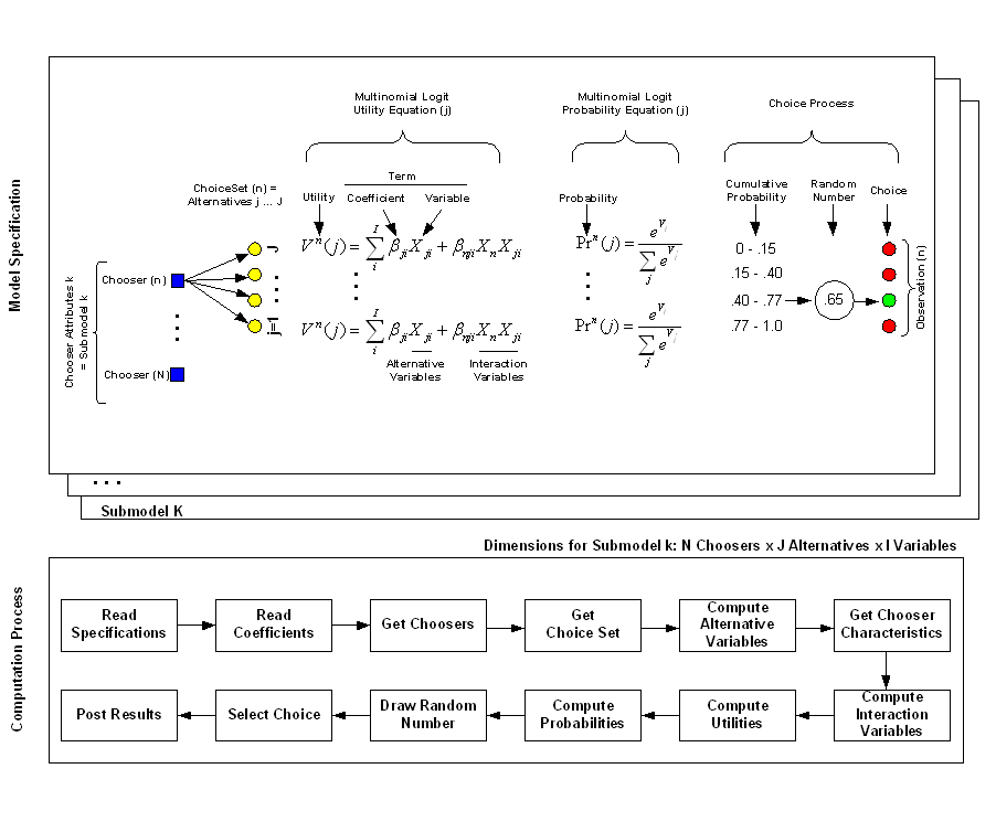 Computation Process in UrbanSim Choice Models
The choice step in this algorithm warrants further explanation. Choice models predict choice probabilities, not choices. In order to predict choices given the predicted probabilities, we require an algorithm to select a specific choice outcome. A tempting approach would be to select the alternative with the maximum probability, but unfortunately this strategy would have the effect of selecting only the dominant outcome, and less frequent alternatives would be completely eliminated. In a mode choice model, for illustration, the transit mode would disappear, since the probability of choosing an auto mode is almost always higher than that of choosing transit. Clearly this is not a desirable or realistic outcome. In order to address this problem, the choice algorithm used for choice models uses a sampling approach. As illustrated in the figure above, a choice outcome can be selected by sampling a random number from the uniform distribution in the range 0 to 1, and comparing this random draw to the cumulative probabilities of the alternatives. Whichever alternative the sampled random number falls within is the alternative that is selected as the ‘chosen’ one. This algorithm has the property that it preserves in the distribution of choice outcomes a close approximation of the original probability distribution, especially as the sample size of choosers becomes larger. The figure below shows an example of a probability surface of a firm selecting a particular parcel in a metropolitan area where red indicates areas more attractive to firms.
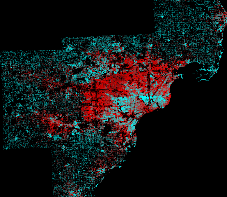
Example of the probability of a firm selecting a particular parcel within the greater Detroit, MI metro area
We have also developed an alternative choice algorithm that enables the model to simulate shortterm market clearing processes. We compute the probability step of the location choice model, sum the probabilities at each submarket to compute aggregate demand, and use this estimate of demand to compare to the available supply in the submarket. Prices are adjusted iteratively, and the relevant components of the location choice model are updated to reflect the influence of the adjusted prices. This algorithm captures more realistically the feedback loop between excess demand for locations causing prices there to increase, which in turn, dampens demand as the submarket becomes relatively more expensive than other submarkets that are substitutes. This variant of the choice process is shown in the figure below.
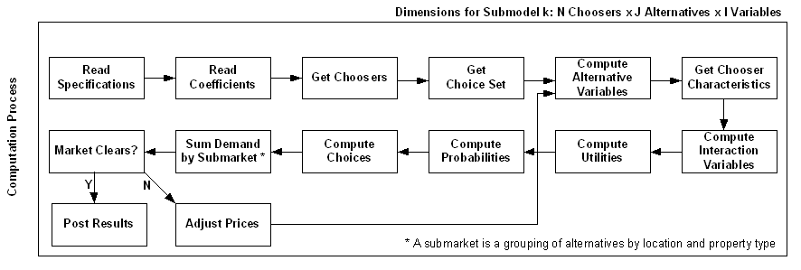 Choice Process With Price Adjustment in UrbanSim Choice Models
References