Travel Model Integration
UrbanCanvas Modeler does not currently have a built-in travel model, however there are a number of ways of incorporating external travel data into the UrbanSim land use model, including by integrating with a local travel model.
Incorporating accessibility into UrbanSim
There are currently four ways of incorporating accessibility metrics into UrbanSim:
1. Pre-loaded: Street networks
Included out-of-the-box with each UrbanSim model is the capability to calculate accessibility metrics based on street-network based accessibility queries. If no other travel data is provided by the user, then street network distance-based accessibility metrics are used to represent regional accessibility in the model. An example of such an accessibility variable would be “employment within 30 kilometers along the street network”. By default, fine resolution OpenStreetMap street networks are used to represent local streets for a region’s automobile network. Custom networks can be uploaded into the platform to be configured for use with UrbanSim or to be used for visualization on the map.
2. User-supplied: Custom transportation networks
Network uploaders are available for directed and undirected transportation networks in graph (e.g. node and edge tables) or shapefile geometry form. These networks can be used in place of the default OpenStreetMap street networks UrbanSim provides by setting a network inside of a scenario for the simulation start year. See how to incorporate networks into scenarios (for the block model, for the zone model, and for the parcel model). The user specifies which pre-uploaded network will apply in each simulation year. Networks can be of any type as long as the network graph or shapefile data schema is followed and can include but are not limited to: travel model networks, automobile, pedestrian, or transit networks. Total-simulation run times may increase with the use of fine resolution networks.
3. Static travel model skims:
Uploading static travel model skims for the block model (schema and upload), for the zone model (schema and upload), and for the parcel model schema) and upload) that provide travel data for a user-specified year. See how to incorporate skims into scenarios (for the block model, for the zone model, and for the parcel model). The user specifies which pre-uploaded skims will apply in each simulation year. This static-skim mode means that accessibilities are influencing the land use model, but not vice-versa. The option of running the simulation in static-skims mode is available for users who are unable to integrate UrbanSim with their local travel model, or those who desire faster total-simulation run time (travel models are relatively long-running).
Travel Model Interface
4. Dynamic travel model skims: Travel model and UrbanSim two-way feedback
The most comprehensive method is connecting your travel model directly with UrbanSim in order to facilitate a two-way land use and travel model feedback loop. This can be completed through a consulting contract to set up the initial connection.
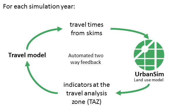
Travel and land use model two-way feedback
The process:
UrbanSim simulates the first time period and then pauses when a travel model year is reached;
UrbanSim exports zonal indicators to a local travel model;
The local travel model runs using the downloaded zonal indicators and then uploads the resulting skims (updated accessibilities) to UrbanSim;
When UrbanSim detects the new uploaded skim file, it proceeds with the next simulation time period until either the next travel model year is reached or until the simulation end-year is reached.
Typically for four-step travel models, the first model in the process is the trip generation model, and this uses zonal population and employment characteristics. When UrbanSim is connected to a travel model system, it generates a summary of the household and job data at a zone level, in order to create the summary input data needed by the travel model.
When the travel model completes the fourth step of traffic assignment to a transportation network, it can produce skims from zone to zone that summarize key model predictions, such as:
Travel time by mode by time of day by purpose
Trips by mode by time of day by purpose
Composite utility of travel using all modes by purpose
Generalized costs (time + time equivalent of tolls) by purpose
Logsums, or composite utilities, from the mode choice model, by purpose and time of day
These skims can be combined with the spatial information in UrbanSim regarding the location of households and jobs, to produce a variety of accessibility measures, which in turn can influence UrbanSim models of residential location, workplace location, employment location, real estate prices, and real estate development. In some applications, the travel model system can be based on a more sophisticated activity-based framework.
System requirements for travel model integration
A travel model that can be run via the command line and the ability to download files from UrbanSim and upload files to UrbanSim from the travel model machine or data storage system.
Note
At this time simulations can be kept alive for a maximum of two weeks to facilitate communication with longer running travel models. Contact us here if your travel model typically runs longer than two weeks.